Day 1
Devil's Postpile and Rainbow Falls ~ 5.5 miles. Great hike and well worth it to a unique geological feature, with hexagonal columns up to 60 feet tall. Rainbow falls, albeit not unique was still a very impressive waterfall at 101 feet from base to top of falls.
Devil's Postpile and Rainbow Falls ~ 5.5 miles. Great hike and well worth it to a unique geological feature, with hexagonal columns up to 60 feet tall. Rainbow falls, albeit not unique was still a very impressive waterfall at 101 feet from base to top of falls.


Mono Lake South Tufa Area and Panum Crater Plug Trail ~ 2 miles.The tufa (stalagmite-resembling towers of salt) form at the bottom of Mono lake due to the extremely high salinity. This area of the lake has been exposed due to slowly drying up levels of water, leaving these interesting formations exposed. Also visible in this area are the millions of alkali flies that live along the edges of the lake. Yes, that picture of "black" shoreline is actually a bed of flies. Apparently, one of the issues of the past has been people removing pieces of Tufa, hence the very interesting sign.
After the tufa, we went on to Panum Crater to explore the remains of an old volcanic eruption. Two very interesting types of rock formed under volcanic conditions are Obsidian and Pumice. This was a great opportunity to appear to be 10x stronger than in reality with the amazingly lightweight Pumice that was found everywhere.


Black Point Hike ~ 3 miles RT, Looking for some slot canyons and fissures in the plateau near Mono Lake, but hard to find the fissures as the instructional sheet of paper from the visitor's center had very poorly designed instructions. They recommended circling the south side of a sandy hill in order to slowly walk up in a switchback fashion. I would suggest going straight up to the peak (perpendicular to the road), and then you can see the fissures from the top. However, the roundabout manner at least allowed us to meet a reptile friend. . They were pretty incredible slot canyons between 1 and 4 feet wide, 10 to 50 feet tall, and in some cases hundreds of feet long. Some of them started and ended in the plateau---as in they did not end at an open cliff. Very enjoyable day hike if you can find them. It was nearing dusk as we finished, and we got treated with a sunset on the way back to the car.


Day 2
Saddlebag and 20 Lakes Basin Loop Hike ~ 6 miles in a loop at 10000 feet around a number of lakes just north of CA 120, Tioga Pass Rd. You can make it a couple miles longer by not taking the ferry across the largest of the lakes- Saddlebag. Great examples of alpine scenery.
Saddlebag and 20 Lakes Basin Loop Hike ~ 6 miles in a loop at 10000 feet around a number of lakes just north of CA 120, Tioga Pass Rd. You can make it a couple miles longer by not taking the ferry across the largest of the lakes- Saddlebag. Great examples of alpine scenery.


Bennettville Mine and Town Hike ~ 4 miles. This mining town has a particularly interesting history. A propspector laid claim to have found a gold nugget on top of a mountain, and was able to generate the investment needed in order to gather large amounts of mining equipment for the operation. Unfortunately after the town expanded greatly, the prospector led mining teams to make many pilot shafts and adits, and a road had been built to the area, no further gold was found. In fact, this all happened to quickly that the post office was only open for a few months. What is most interesting about this town is that the road that was built was in fact Highway 120, the famous Tioga Pass road that allows entrance into Yosemite from the east.


Lakes Canyon to May Lundy Mine ~ 6 miles, Drive towards this resort lake area, and cross over the dam at the east end of Lundy Lake, and hike southwest up an old road at constant grade for 3 miles. (By constant grade I mean there is not a single place on that road that you could have placed a ball without it rolling down the trail--I had never seen so constant of a slope on a road). The hike itself was grueling, but when we got the 1780 feet up we were standing on a 100 foot+ tall pile of tailings, with a closed mine on one side, a valley with a lake a few hundred feet below us, and the remains of about 4 or 5 buildings with about 50 different pieces of large equipment strewn all over. Boilers, ore carts, ovens, weird cogs and gears, turbine looking devices, etc. This is on the list to explore again in the future.
Day 3
Rock Creek Lakes Hike ~ 4-5 miles, on Rock Creek Rd out of Tom's Place on US395. It was nice and "majestic" with sweeping meadows, lakes every 1/2 mile to 1/4 mile, and mountains around us, but we had seen a lot of these in the previous 2 days, so we turned around and came back. Also, a very crowded trail for the area.
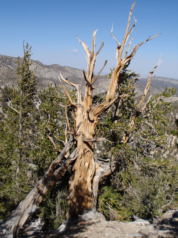
Ancient Bristlecone Pine Forest - Methuselah Loop ~ 4.5 miles, Very weird, twisted trees. Incredible that they can look like completely normal pine trees when they grow in proper soil, but the fact that they can barely survive in alkaline soil is what allows them to be the oldest, since they end up growing very dense wood, which in turn protects them from disease, insects, fire, drought, etc. And in this dense form they twist and turn as the hillside erodes and grows, and depending on predominant wind conditions. It was slightly disappointing not being able to figure out precisely which one of the trees on the trail was Methuselah, the oldest tree in the world, but they don't tell you so as to protect it from idiots with chainsaws. Marie and I agree that we would recommend this to be done once, but would probably not come back for a few years. The trees started getting repetitive by the 3rd mile. Maybe a different trail would be better, although we chose this one for the views into Death valley, which were also interesting.
Rock Creek Lakes Hike ~ 4-5 miles, on Rock Creek Rd out of Tom's Place on US395. It was nice and "majestic" with sweeping meadows, lakes every 1/2 mile to 1/4 mile, and mountains around us, but we had seen a lot of these in the previous 2 days, so we turned around and came back. Also, a very crowded trail for the area.
Ancient Bristlecone Pine Forest - Methuselah Loop ~ 4.5 miles, Very weird, twisted trees. Incredible that they can look like completely normal pine trees when they grow in proper soil, but the fact that they can barely survive in alkaline soil is what allows them to be the oldest, since they end up growing very dense wood, which in turn protects them from disease, insects, fire, drought, etc. And in this dense form they twist and turn as the hillside erodes and grows, and depending on predominant wind conditions. It was slightly disappointing not being able to figure out precisely which one of the trees on the trail was Methuselah, the oldest tree in the world, but they don't tell you so as to protect it from idiots with chainsaws. Marie and I agree that we would recommend this to be done once, but would probably not come back for a few years. The trees started getting repetitive by the 3rd mile. Maybe a different trail would be better, although we chose this one for the views into Death valley, which were also interesting.


 RSS Feed