Peter Scranton Adventures
  • My Adventures
  • About Me

Mt Williamson and Tyndall attempt

7/6/2011

0 Comments

 
Picture
Well, this previous weekend we attempted to do a double 14er weekend in the Sierras. Unfortunately, it's our first mountain weekend that's defeated us...

We left Redondo Beach at 5:15am on Friday, and arrived at the Eastern Sierra Interagency Visitor Center in Lone Pine, CA around 10:00am. We got the last 3 overnight permits for the day, for 3 nights out of Shepherd's Pass trailhead.  After a quick bite at Alabama Hills cafe (awesome breakfast and lunch to load up before a long weekend), we drove down some of the wrong, rarely used 4x4 trails to get to the Shepherd's pass hiker trailhead.

At 12:30pm, we were on the trail and within 15 minutes finding ourselves jumping out of our boots and socks for our first water crossing.  We were able to bypass the 2nd and 3rd crossings via a use trail on the north side of Symmes creek, and then had to de-boot for the 4th crossing. This was the end of any easy hiking, and we began up 55 switchbacks and 2500 feet to a series of 3 saddles, and then dropped back down 500 feet to Mahogany Flats.  

Picture
At this point, we were fairly exhausted and had been taking it easy (now being at 9000 feet and having slept at sea level only 12 hours before).  However, the campsites had poor water access, so we pushed on to Anvil Camp. This entailed our first snow/ice crossings, and I whipped out the ice axe, with Andrew comfortably using poles.  We arrived at 10,300 foot Anvil Camp after 8 miles and over 4000 feet of gain, then set up camp and made a quick meal of fajitas before going to sleep just after dusk. 

Picture
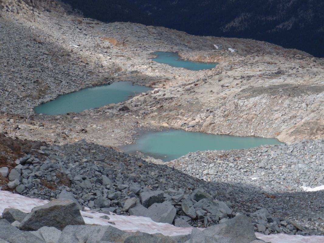
We awoke casually on Saturday and were packed, fed, and on the trail by 9am. By 11am we were at Shepherd's pass, at over 11500 feet and 4 miles up many snow crossings. At this point I already had the gaiters on and ice axe out, but now I needed to put on the crampons like everyone else and proceed to climb Shepherd's pass 

Picture
 After reaching the top of the pass, we dropped our packs, searched for water as all the lakes were frozen over, and found a trickle of snowmelt about 10 minutes away from our packs. After setting up camp, eating lunch, and repacking light, we proceeded toward Mt. Tyndall, our first 14er objective of the weekend. We filled up our water on the way, and began climbing the endless talus. Marie started getting nauseous and signs of altitude sickness, and after slowing down signficantly, we got to 13,600 feet where she stopped. The other two of us proceeded to the top of the ridge, at 13880 feet and discovered a false summit which would require another 30-40 minutes to navigate around to the true summit. As a result, we snapped those pictures at the false summit, turned around, and slowly backed down the mountain. Once we made it back to camp around 7:30pm, we had a chat with some others staying at Shepherd's pass, then made food and hit the sack. 

Picture
Sunday morning we were still not feeling great, after our first true exposure to altitude sickness, and so we decided to play it safe and hike back out to the trailhead.  We made it out with no issues and got home late that evening.

0 Comments

Mammoth Snowshoeing

3/6/2010

0 Comments

 
Spent a weekend with friends in Mammoth. While they were off skiing and snowboarding, we brought our snowshoes with us and went on some short hiking trips into the cold trails of the area. 

Trail 1: Twin Lakes - Lake Mary Loop (Tamarack Cross Country Ski Center) - 5.5 miles
This was a fairly tame introductory snowshoeing hike, with about 30% semi-packed and the rest fresh powder. The trail we chose traverses some preset loops around the Lake Mary area of Mammoth Lakes, starting by Twin Lakes, passing north of Lake Mary, and getting views of Horseshoe Lake, heading south around all the lakes, and then back to the start. On the return trip, we split away from the trail for an exploration of the Panorama Dome, which we were surprised to find had only one or two sets of prints at that time. Coming back down required some navigation of backcountry, as the only trails up were from the south, in the opposite direction of where we planned to go. 

Trail 2: Obsidian Dome (June Lake area) - 6 miles
This was a short drive north along 395 from Mammoth, and the main trail itself was fairly tame. The semi-groomed path runs straight to the dome, and then loops around it in one big circle. Overall, the scenery was pleasant and the deer were abundant on this portion of the trail. However, not satisfied with the level of ruggedness to our snowshoeing adventures, we decided to cross country up some hills toward the top of the dome (or a mini-dome, it was hard to tell in the white wilderness). The terrain was fairly steep, and we were able to truly test our kick stepping as we zigzagged our way up the side of the hill. The view from the top was great, and we even were able to glissade down a few sections and save some time back, although we were more jealous of the cross country skier that was there sometime earlier in the morning. 

Trail 3: Shady Rest Park Loops (Mammoth Lakes Town area) ~3.5 miles
Desiring a little more mileage, we took this stroll on what seemed to be a combination golf course and park during the summer season. It was extremely easy and mostly just gave us a chance to get some exercise in the form of speed-snowshoeing in a big loop. Recommended as a warm up. 
0 Comments

Mt. Lyell - Yosemite NP Backpacking

9/13/2009

0 Comments

 
Picture
Mt. Lyell is the tallest peak in Yosemite NP at 13114 feet, and regarded by many peakbaggers as having some of the most impressive views of the Sierras based upon it's proximity to many other highpoints (with the others being Mt. Brewer in King's Canyon and Mt. Hoffman in Yosemite near May Lake). 

For this trip, Marie and I camped out along Hwy 120 at one of the many small Inyo NF campgrounds on the east entrance, and met up with Aaron at the ranger station early the next morning. We were easily able to nab a walk up permit for backpacking via Lyell Canyon from the Tuolomne Meadows Trailhead. After organizing our gear, we set off for our base camp at the upper portion of Lyell Canyon, just below the tree line. There were 3 or 4 campsites on the west side of the river, which provided plenty of ample water flow still in early September. 

The next morning we awoke leisurely, as the peak was only a few miles away at this point, and hiked up to Lyell pass, the edge of Yosemite NP, before turning west towards the peak. The approach was mostly clear of boulders until the last mile, which began turning into dense scree. We passed a couple who had turned around for fear of some ominous storm clouds, but we were keeping a watchful eye on them the whole time, and in fact didn't hear our first bit of thunder or see any lightning (on another, very distant peak) until we had actually reached our own summit. 
When we reached the large Lyell glacier, we immediately wished we had crampons in our packs, as the trip around them to the north added easily an extra 30 minutes over just climbing straight up the glacier to the final summit approach. There was a point at which due to the distance and perspective of the mountain, it seemed impossible to scale without ropes, and had it not been for Marie pushing us along, we would have never summited. Sure enough, she was right (as she always is) and we found the final summit climb very easy with minimal exposure. The summit was beautiful, and showed an impressive set of afternoon storm clouds in the distance which caused us to go back down with haste. We reached our basecamp well before dark, and leisurely packed out the next day, making for a very enjoyable and relaxed backpacking trip to a beautiful summit. 
0 Comments

Mono Lake, Devil's Postpile, and Saddlebag Lake

8/28/2009

0 Comments

 
Day 1 

Devil's Postpile and Rainbow Falls ~ 5.5 miles. Great hike and well worth it to a unique geological feature, with hexagonal columns up to 60 feet tall. Rainbow falls, albeit not unique was still a very impressive waterfall at 101 feet from base to top of falls. 
Picture
Mono Lake South Tufa Area and Panum Crater Plug Trail ~ 2 miles.The tufa (stalagmite-resembling towers of salt) form at the bottom of Mono lake due to the extremely high salinity. This area of the lake has been exposed due to slowly drying up levels of water, leaving these interesting formations exposed. Also visible in this area are the millions of alkali flies that live along the edges of the lake. Yes, that picture of "black" shoreline is actually a bed of flies. Apparently, one of the issues of the past has been people removing pieces of Tufa, hence the very interesting sign. 

After the tufa, we went on to Panum Crater to explore the remains of an old volcanic eruption. Two very interesting types of rock formed under volcanic conditions are Obsidian and Pumice. This was a great opportunity to appear to be 10x stronger than in reality with the amazingly lightweight Pumice that was found everywhere. 
Black Point Hike ~ 3 miles RT, Looking for some slot canyons and fissures in the plateau near Mono Lake, but hard to find the fissures as the instructional sheet of paper from the visitor's center had very poorly designed instructions. They recommended circling the south side of a sandy hill in order to slowly walk up in a switchback fashion. I would suggest going straight up to the peak (perpendicular to the road), and then you can see the fissures from the top. However, the roundabout manner at least allowed us to meet a reptile friend. . They were pretty incredible slot canyons between 1 and 4 feet wide, 10 to 50 feet tall, and in some cases hundreds of feet long. Some of them started and ended in the plateau---as in they did not end at an open cliff. Very enjoyable day hike if you can find them. It was nearing dusk as we finished, and we got treated with a sunset on the way back to the car. 
Day 2

Saddlebag and 20 Lakes Basin Loop Hike ~ 6 miles
in a loop at 10000 feet around a number of lakes just north of CA 120, Tioga Pass Rd. You can make it a couple miles longer by not taking the ferry across the largest of the lakes- Saddlebag. Great examples of alpine scenery. 

Read More
0 Comments

    Author

    A documentation of all the trips I take, from sailing adventures aboard "Ship Happens" to offroad expeditions with "Sarge", to summits of peaks around the world, and of course an update on my personal quest to visit all 59 US National Parks. 

    Archives

    November 2013
    September 2012
    July 2011
    May 2010
    March 2010
    February 2010
    January 2010
    December 2009
    November 2009
    September 2009
    August 2009
    April 2009
    March 2009
    February 2009
    October 2008
    August 2008

    Categories

    All
    14er
    Backpacking
    Caving
    Desert
    Hiking
    Kayaking
    Offroad
    Sailing
    Sierra

    RSS Feed

Site powered by Weebly. Managed by Hostmonster